
7.1 Watershed Impacts#
Humans are agents of change in the CZ. Here we focus on the land/water connection and on how human-induced land use change affects local hydrology. You will apply what they learned in the previous modules about how hydrologists use data (land-cover type, soil texture, and slope) to predict the amount and destination of water as it moves through a built environment. You will use the Model My Watershed application to evaluate the impact of human alterations to the landscape and will also investigate how best-management practices can lesson those impacts. While doing so, you will also consider impacts to society both from the increased runoff and from some mitigation measures.
In this section, you will:
describe a watershed and delineate a watershed on a map;
identify the key factors in a watershed that impact runoff and sediment yield, describe how increased storm-water runoff affects landscapes (e.g., erosion, channel incision, sedimentation) and describe how those factors are impacted by human development;
evaluate the impact of human alterations to the landscape and investigate how best-management practices can lessen those impacts;
compare social and economic impacts to society from both runoff changes and from mitigation measures;
analyze how neighborhood redevelopment can affect local communities, to their benefit and/or to their detriment.
Watersheds#
Watershed is a land where all of the water that falls or flows within it drains into a final receiving body of water, such as a river, lake, or ocean. The boundaries of a watershed are defined by the topography of the landscape, with higher elevations forming ridges or divides that separate one watershed from another.
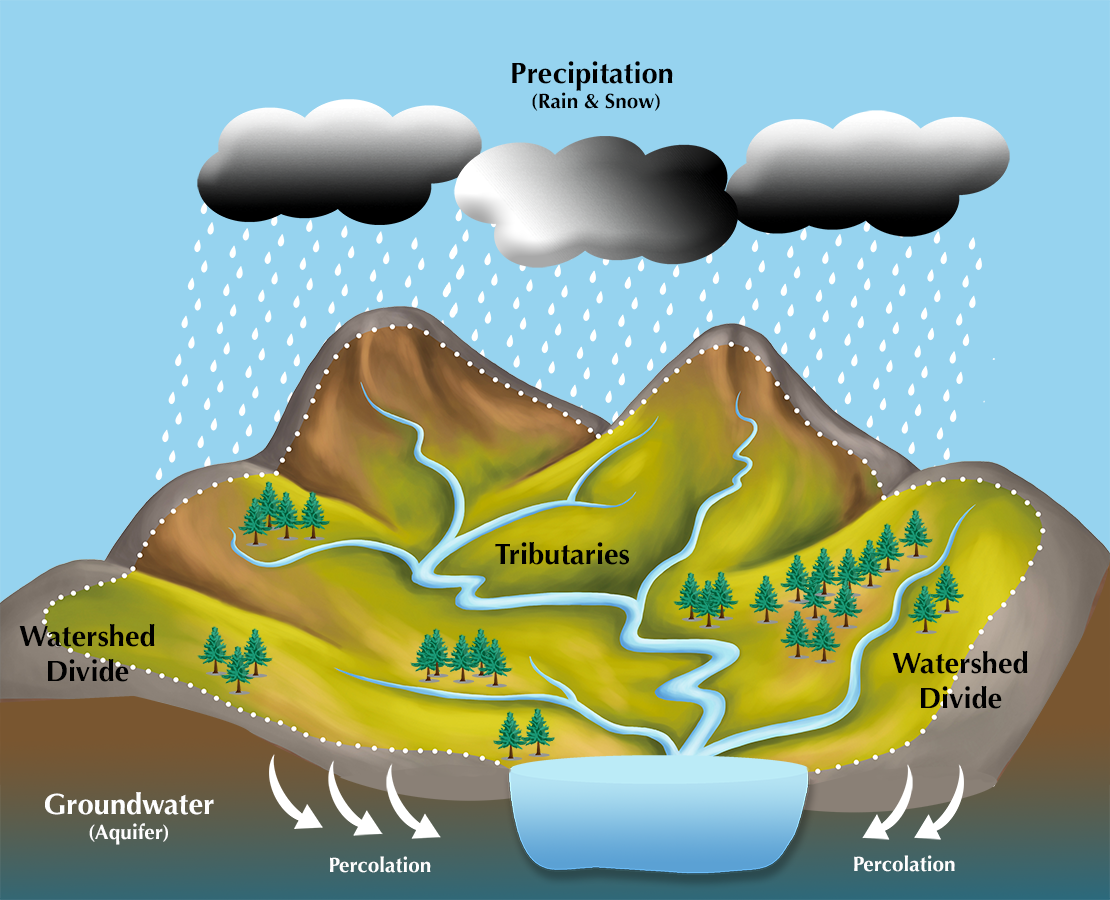
Fig. 46 A watershed is the land area that drains to a common body of water, such as a stream, lake, bay, or even the ocean.#
Watersheds can range from small first order streams to large river basins that encompass large bodies of land at continental scales. They play a critical role in the hydrological cycle by capturing and storing precipitation and releasing it slowly over time, providing water for human consumption, irrigation, and industrial uses, and supporting aquatic ecosystems. Understanding the boundaries, characteristics, and functions of watersheds is essential for effective land and water management, conservation, and restoration efforts.
Explore the watersheds of the southeastern US in the USGS National Map below (turn on the Watershed Boundary Dataset in the layers button):
What’s in our Watersheds#
We have previously used StreamStats | U.S. Geological Survey (usgs.gov) to delineate watersheds at small scale. Here we will explore another application called Model My Watershed to learn a bit more about what’s in our watersheds. Follow the instructions below to try this application.
Model My Watershed
Let’s use Model My Watershed® - WikiWatershed which is an interactive web-based hydrologic modeling tool that allows users to calculate water budgets for various storm intensities, generic land-cover types, and soil textures for a generic patch of land (“Micro model”) or for an area you have defined in your own watershed (“Watershed model”).
Zoom into some area of interest;
For rural watershed-scale areas, turn on HUC-12 Watershed boundaries using “Select by Boundaries”.
For smaller urban areas, use “Draw Area” to define your area of interest.
Analyze Tab contains:
Land Tab - Bar chart of % Landcover
Soil Tab - Bar chart of % Soil infiltration capacity
Animals Tab - Farm census for your area
Point Sources (if any) from EPA NPDES (National Pollutant Discharge Elimination System)
Water Quality - Delaware River Basin only
Model tab (Site Storm Model (with precipitation controlled by slider) or Watershed Multi-year (annual) Model
Runoff/Hydrology tab - Water budget components: graphs (above), table (below)
Water Quality tab - Water Quality component tables: Landcover source zone (above), TMDL (below)
Do these make sense based on what you know about the area?
How does amount of precipitation affect the water balance? (site storm model)
Which seasons contribute the most sediment to the stream? Why? (multi-year model)
Stormwater Runoff and Pollution#
Stormwater runoff pollution is the contamination of water that occurs when rainwater or melted snow flows over the ground and into storm drains, rivers, lakes, or other bodies of water. As the water flows over the land, it can pick up various pollutants such as oil and grease, pesticides, fertilizers, animal waste, litter, and sediment. These pollutants can have harmful effects on the water quality and can lead to a variety of environmental problems.
One of the major sources of stormwater runoff pollution is urbanization, which increases the amount of impervious surfaces such as roads, parking lots, and buildings. These surfaces prevent water from soaking into the ground and instead cause it to flow rapidly over the surface, picking up pollutants along the way.
To learn about the water quality issues in your community waterways, see How’s My Waterway - Community (epa.gov).
Stormwater BMPs#
The primary method to control stormwater runoff is the use of best management practices (BMPs). Stormwater BMPs are devices, practices, or methods that are used to manage stormwater runoff by controlling peak runoff rate, improving water quality, and managing runoff volume.
Examples of BMPs include reducing the amount of impervious surfaces, using permeable paving materials, and implementing green infrastructure such as rain gardens and bioswales. Additionally, individuals can help reduce stormwater runoff pollution by properly disposing of trash, chemicals, and other pollutants, and by minimizing the use of fertilizers and pesticides on their lawns and gardens.
Investigate various water management best practices in urban/suburban neighborhoods. You can research various BMPs and investigate the appropriate use of these measures. You can select locations in an area of your interest and develop designs using BMPs, to address problematic areas where runoff produces problems. Individual students or teams will report back to the class on their designs, both orally and using a handout for the class to use for discussion purposes.